Manus Province (Manus Province)
 |
The province consists of only one district (Manus District; with identical boundaries to those of the province), 12 Local Level Governments (LLGs) and 127 Wards.
The province is made up of the Admiralty Islands (a group of 18 islands in the Bismarck Archipelago), as well as Wuvulu Island and nearby atolls in the west, which collectively are referred to as the Western Islands. The largest island in the group is Manus Island, where Lorengau and a former Australian immigration detention centre are located.
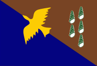
The Manus friarbird, known locally as the chauka, is represented on the Manus provincial flag. Designer of the Manus Province flag Luke Bulei explained his reasons for its design in 1977: chauka is only found in the Manus province; it heralds dawn and signals sunset; it often warns us of dangers; and lastly, it informs us of the success or otherwise of a forthcoming hunting trip. He added that NBC Radio Station had changed its name to Maus Bilong Chauka several years before. He explained that the colour brown on the flag represents the inland people and the blue represents the island people. The other important symbol on the flag is the green snail, which is also unique to the Manus province.
Map - Manus Province (Manus Province)
Map


Country - Papua_New_Guinea
 |
 |
| Flag of Papua New Guinea | |
At the national level, after being ruled by three external powers since 1884, including nearly 60 years of Australian administration starting during World War I, Papua New Guinea established its sovereignty in 1975. It became an independent Commonwealth realm in 1975 with Elizabeth II as its queen. It also became a member of the Commonwealth of Nations in its own right.
Currency / Language
| ISO | Currency | Symbol | Significant figures |
|---|---|---|---|
| PGK | Papua New Guinean kina | K | 2 |
| ISO | Language |
|---|---|
| EN | English language |
| HO | Hiri Motu language |